California Marbled Murrelet Forest Survey Form
ADVERTISEMENT
 1
1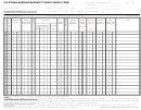 2
2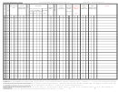 3
3CALIFORNIA
1
Survey Visit to Protocol
Page
of _____
Total Detections:
(Y or N, initials):
_______
MARBLED MURRELET
Species of Concern (circle one, details on last pg.): Y or N
FOREST SURVEY FORM
Month ____________ Day ________ Year ________
Area Name: _____________________________
Site Name / Number: ________________________
Station Number: __________
Sta. Location - UTM zone: ____ E (x) coordinate: ___________ N (y) coordinate: ___________ Source: ______ Datum: ______ FOM:____
Observer (s) Name: _______________________
Initials:_______ Affiliation: ___________________ Phone: (____)_______________
Station Elevation: __________ Ft / M
Position on Slope (circle one): Bottom/plain, Lower 1/3, Mid 1/3, Upper 1/3, Ridgetop
Station Placement (circle one): Inside, Outside
Distance from Survey Site Boundary: _____________
Units of Measure for ALL Horizontal Distances: ____________
Station Canopy Cover (circle one): 1 = 0 to 25%, 2 = 26 to 50%, 3 = 51 to 75%, 4 = 76 to 100%
Canopy Height ______________
ENVIRONMENTAL CONDITIONS:
Official Sunrise Time: __________
Source: __________
Begin Survey Time: __________ End Survey Time: __________
Temperature at Sunrise: __________
Temperature at End of Survey: __________ (circle one) C or F
revised: 2 / 2000
TIME
VERTICAL VIEWING
HORIZ.
AUDIBILITY
PRECIPITATION
WIND
NOISE
NOTES
VIS.
TO
TO 100 M
200 M
VISIBILITY
RAIN
FOG
OTHER
TO 2
CANOPY
Ceiling: UL = Unlimited (clear), HI = >2.0 canopy height, MID = >1.25 to < 2.0 canopy height, LO = <1.25 canopy height, U = Unknown.
Cloud Cover: 0 = 0%, 1 = 33%, 2 = 66%, 3 = 100%.
Vertical Visibility: N = Impaired (detections may be missed due to conditions), Y = Unimpaired (conditions allow for reliable detection), U = Unknown.
Horizontal Visibility: N = Impaired (detections may be missed due to conditions), Y = Unimpaired (conditions allow for reliable detection), U = Unknown.
Audibility: N = Impaired (detections may be missed due to conditions), Y = Unimpaired (conditions allow for reliable detection).
Precipitation - Rain & Fog: N = None, L = Light, M = Moderate, H = Heavy. Other: H = Hail, S = Snow. (Indicate intensity using same codes for rain & fog).
Wind: 0 = <1 mph (calm), 1 = 1-3 mph (leaves barely move), 2 = 4-7 mph (leaves rustle, sm. twigs move), 3 = 8-12 mph (leaves & sm. twigs in constant
motion), 4 = 13-18 mph (sm. branches move), 5 = 19-24 mph (lg. branches & sm. trees start to sway), 6 = 25-31 mph (lg. branches in constant motion), 7 = 32-38
mph (whole trees move), 8 = 39-46 mph (twigs & sm. branches break).
Noise: N = None, A = Aircraft, B = Bird song/calls, C = Creek/water drainage, M = Machinery, P = Rain/hail, T = Tree drip, V = Vehicle, W = Wind,
O = Other (explain in Notes).
Occurrence No. __________
Data Point No. ___________
Sequence No. ______________
Reference No. ___________
Quad. Code ____________
Photo Code _____________
General Location _____________________________________
Data Entry Initials _________
Data Entry Date ___________
Data QC Initials ___________
Data QC Date ___________
Protocol Review Initials __________
Review Date _______________
Highest Biological Status __________
** CDFG DATABASE USE ONLY **
ADVERTISEMENT
0 votes
Related Articles
Related forms


 Application Form")


Related Categories
Parent category: Life