Culvert Installation Or Maintenance In Fish Streams Permit Application Form - Alaska Department Of Fish And Game
ADVERTISEMENT
 1
1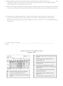 2
2 3
3FG# __________________________________
(FOR OFFICIAL USE ONLY)
ADF&G - HABITAT AND RESTORATION DIVISION
AS 16.05.840 or 16.05.870 Permit Application Form
Culvert Installation or Maintenance in Fish Streams
Applicant: ________________________
Date Submitted: _______________________
________________________
Project Location: _______________________
________________________
_____________________________________
USGS Quadrangle: ________________
Legal Description: Section _______________
Township _____ Range _____ Meridian ____
1. Name of Waterbody:
_________________________________________________________
1a. ADF&G Anadromous Catalog Number (if applicable): ____________________________
2. Culvert Type and Dimensions
(check one)
o CMP
(a) Length _______(ft.) (b) Diameter _______(ft.) (c) Corrugation _______(in.)
(Corrugations: 6 in. by 2 in.; 1/2 in. by 3 in., etc.)
o Multiplate (a) Length _______(ft.) (b) Diameter _______(ft.) (c) Corrugation _______(in.)
o Pipe Arch (a) Length _______(ft.) (b) Arch Span ______(ft.) (c) Arch Rise _________(ft.)
(d) Bottom Radius ______________(ft.) (e) Corner Radius
______________(ft.)
o Other (including baffled culverts):_______________________________________________
(please provide complete specifications including length, diameter or span, corrugation size, baffle height,
angles and spacing, etc.)
4. Floodplain o Gorge
o V-Shaped
3. Stream Type: _________________________
o Flat/Wide o Terraced
Type:
(see page 2 for stream type classifications)
5. Slope of Natural Stream: ______________%
6. Culvert Slope (invert): ____________%
(measure stream slope along length of stream one
culvert length above and below culvert)
7. Bankfull Width: ____(ft.) 8. Bankfull Depth: ____(ft.) 9. Floodplain Width: _____(ft.)
10. Culvert Invert Elevation (Depression) Relative to Stream Thalweg (ft.): _____________(ft.)
(the thalweg is a line following the deepest part of the stream channel)
11. Stream Substrate Size:
o Bedrock
o Boulder
o Cobble
o Gravel
o Sand
o Silt/Clay
12. Mean Annual, Two Day Duration Flood (Q
)
2
Hypothetical Stream Hydrograph Depicting
Two-Day Duration Delay For the Design
Discharge
_____________________________(cfs)
: _
Discharge
12
10
Design
(Unless otherwise specified by the ADF&G, the fish passage design
Discharge
8
discharge is the mean annual, two day duration flood for the specific
6
time of year that the design fish is migrating upstream. The ADF&G
4
is responsible for identifying the design fish species and the time of
2
0
year fish passage is required.)
Days
13. Fifty-Year (Q
) Flood Discharge: ___________(cfs)
50
C:\homepage\culv-app.doc
ver. 5/15/96
ADVERTISEMENT
0 votes
Related Articles
Related forms
 Form Bah - Apprentice Enrollment Application Form - Alaska Department Of Community And Economic Development
Legal
Form Bah - Apprentice Enrollment Application Form - Alaska Department Of Community And Economic Development
Legal
 Transporter License Application Form - Alaska Department Of Community And Economic Development
Legal
Transporter License Application Form - Alaska Department Of Community And Economic Development
Legal
 Form Aels - Application For Opening A File For Retention Of Land Surveyor Work Verification Forms - Alaska Department Of Community And Economic Development
Legal
Form Aels - Application For Opening A File For Retention Of Land Surveyor Work Verification Forms - Alaska Department Of Community And Economic Development
Legal
 Aquatic Farm Operation Permit Renewal Or Transfer Application Form - Alaska Department Of Fish And Game
Legal
Aquatic Farm Operation Permit Renewal Or Transfer Application Form - Alaska Department Of Fish And Game
Legal

 Registered Agent Or Registered Agent Address Statement Of Change Form - Alaska Department Of Community And Economic Development
Legal
Registered Agent Or Registered Agent Address Statement Of Change Form - Alaska Department Of Community And Economic Development
Legal
 Permit Application - Western Australia Department Of Agriculture And Food")


Related Categories
Parent category: Legal