Nps Form 10-900 - National Register Of Historic Places Registration Form Page 17
ADVERTISEMENT
 1
1 2
2 3
3 4
4 5
5 6
6 7
7 8
8 9
9 10
10 11
11 12
12 13
13 14
14 15
15 16
16 17
17 18
18 19
19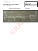 20
20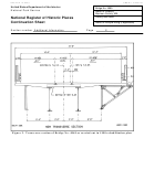 21
21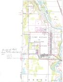 22
22United States Department of the Interior
National Park Service / National Register of Historic Places Registration Form
NPS Form 10-900
OMB No. 1024-0018
Bridge No. 4969
Morrison County, MN
Name of Property
County and State
Primary location of additional data:
____ State Historic Preservation Office
X Other State agency Minnesota Department of Transportation
____ Federal agency
____ Local government
____ University
____ Other
Name of repository: _____________________________________
Historic Resources Survey Number (if assigned):
MO-GRE-049
______________________________________________________________________________
10. Geographical Data
Acreage of Property
0.3
UTM References
Datum (indicated on USGS map):
NAD 1927
or
NAD 1983
X
1. Zone: 15
Easting: 396777
Northing: 5103179
2. Zone:
Easting:
Northing:
3. Zone:
Easting:
Northing:
4. Zone:
Easting :
Northing:
Verbal Boundary Description (Describe the boundaries of the property.)
The boundaries of the property correspond to the physical limits of the bridge and its
abutments.
Boundary Justification (Explain why the boundaries were selected.)
The historic property consists of, and therefore the boundary reflects the physical limits of,
the bridge and its abutments.
Sections 9-end page 17
ADVERTISEMENT
0 votes
Related Articles
Related forms

 - National Park Service - U.s. Department Of The Interior") Nps Form 10-930s - Application For Special Use Permit (short Form) - National Park Service - U.s. Department Of The Interior
Legal
Nps Form 10-930s - Application For Special Use Permit (short Form) - National Park Service - U.s. Department Of The Interior
Legal

 Form Nfp 105.10/105.20 - Statement Of Change Of Registered Agent And/or Registered Office - 2003
Legal
Form Nfp 105.10/105.20 - Statement Of Change Of Registered Agent And/or Registered Office - 2003
Legal

 Form Nfp 105.10/105.20 - Statement Of Change Of Registered Agent And/or Registered Office - 2003
Legal
Form Nfp 105.10/105.20 - Statement Of Change Of Registered Agent And/or Registered Office - 2003
Legal


Related Categories
Parent category: Life