Pasture Lease Agreement Page 25
ADVERTISEMENT
 1
1 2
2 3
3 4
4 5
5 6
6 7
7 8
8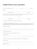 9
9 10
10 11
11 12
12 13
13 14
14 15
15 16
16 17
17 18
18 19
19 20
20 21
21 22
22 23
23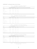 24
24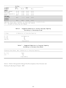 25
25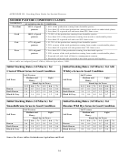 26
26Soil Zone
Vegetation
Dark
Dark
Brown
Black
Gray
Gray
or Site
ASPEN
Normal Upland
0.10
0.10
0.15
0.15
Dune Sand
0.10
0.20
0.15
0.15
Closed Depression
0.10
0.20
0.15
0.15
Thin
N/A
0.10
0.10
0.10
CLEARED
Nonseeded
N/A
-----
0.40
0.40
OTHERS
Wetland
N/A
N/A
0.40
0.40
*Rates are for stands in satisfactory conditions.
N/A:
Not applicable, see the previous two tables.
----
No data or sites are not common
Table 6.
Suggested Reduction in Cattle Carrying Capacity
According to Percentage Slope
% Slope
% Reduction in Carrying Capacity
0 – 10
No Reduction
11 –30
30
31- 60
60
over 60
100
(Ungrazable)
Table 7.
Suggested Reduction in Carrying Capacity
According to Distance From Water
Distance from Water (km) % Reduction in Carrying Capacity
0 – 1,5
None
1,5 – 3
50
> 3
100
(Ungrazable)
Source : Zoheir Abouguendia, Range Plan Development, New Pastures and
Grazing Technologies Project, 1990
23
ADVERTISEMENT
0 votes
Related Articles
Related forms


Related Categories
Parent category: Business