'Origin Of The Hawaiian Islands' Geography Worksheet
ADVERTISEMENT
 1
1 2
2 3
3 4
4Name ________________________________
Regents Earth Science
Origin of the
Mod _______
Date ______________________
Hawaiian Islands
Partner ________________________________
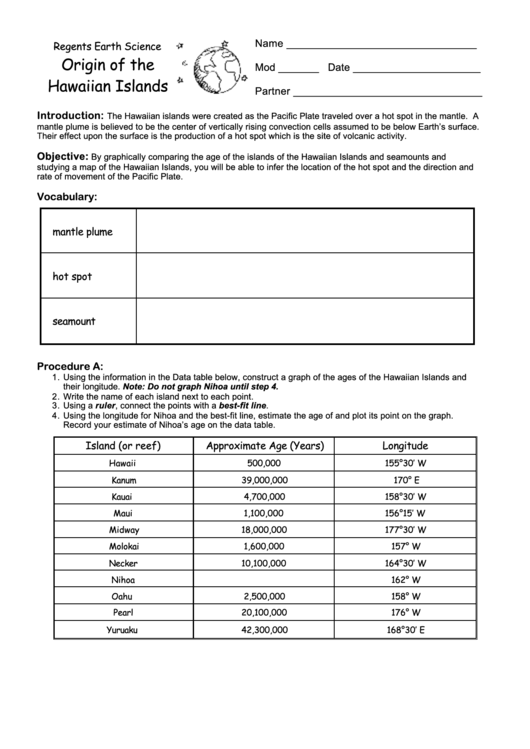
Introduction:
The Hawaiian islands were created as the Pacific Plate traveled over a hot spot in the mantle. A
mantle plume is believed to be the center of vertically rising convection cells assumed to be below Earth’s surface.
Their effect upon the surface is the production of a hot spot which is the site of volcanic activity.
Objective:
By graphically comparing the age of the islands of the Hawaiian Islands and seamounts and
studying a map of the Hawaiian Islands, you will be able to infer the location of the hot spot and the direction and
rate of movement of the Pacific Plate.
Vocabulary:
mantle plume
hot spot
seamount
Procedure A:
1. Using the information in the Data table below, construct a graph of the ages of the Hawaiian Islands and
their longitude. Note: Do not graph Nihoa until step 4.
2. Write the name of each island next to each point.
3. Using a ruler, connect the points with a best-fit line.
4. Using the longitude for Nihoa and the best-fit line, estimate the age of and plot its point on the graph.
Record your estimate of Nihoa’s age on the data table.
Island (or reef)
Approximate Age (Years)
Longitude
Hawaii
500,000
155°30’ W
Kanum
39,000,000
170° E
Kauai
4,700,000
158°30’ W
Maui
1,100,000
156°15’ W
Midway
18,000,000
177°30’ W
Molokai
1,600,000
157° W
Necker
10,100,000
164°30’ W
Nihoa
162° W
Oahu
2,500,000
158° W
Pearl
20,100,000
176° W
Yuruaku
42,300,000
168°30’ E
ADVERTISEMENT
0 votes
Related Articles
Related forms


Related Categories
Parent category: Education