Flood Hazard Area Development Application Form - City Of Waterville Page 3
Download a blank fillable Flood Hazard Area Development Application Form - City Of Waterville in PDF format just by clicking the "DOWNLOAD PDF" button.
Open the file in any PDF-viewing software. Adobe Reader or any alternative for Windows or MacOS are required to access and complete fillable content.
Complete Flood Hazard Area Development Application Form - City Of Waterville with your personal data - all interactive fields are highlighted in places where you should type, access drop-down lists or select multiple-choice options.
Some fillable PDF-files have the option of saving the completed form that contains your own data for later use or sending it out straight away.
ADVERTISEMENT
 1
1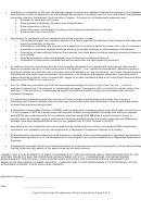 2
2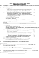 3
3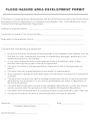 4
4FLOOD HAZARD AREA DEVELOPMENT PERMIT
ADMINISTRATIVE CHECKLIST
NOTE: The following is to be completed by the local floodplain administrator. All references to elevations are in feet mean sea
level (m.s.l.), according to the datum used, NAVD 88, on the effective Flood Insurance Rate Maps.
1.
The proposed development is in:
____
An identified floodway.
Does a hydrologic and hydraulic engineering analysis accompany the application
Y / N
Does the analysis have a certification that flood heights will not be increased
Y / N
Is the analysis certified by a Registered Professional Engineer
Y / N
____
A flood hazard area where base flood elevations exist with no identified floodway.
Does a hydrologic and hydraulic engineering analysis accompany the application
Y / N
Does the analysis have a certification that flood heights will be increased less
than the height designated in the community’s flood damage reduction regulations
(in no case will this be more than one foot)
Y / N
Is the analysis certified by a Registered Professional Engineer
Y / N
____
An area within the floodplain fringe.
____
An approximate flood hazard area (Zone A).
____
Within the banks of a watercourse.
Does an analysis demonstrating that the flood carrying capacity has not been
diminished accompany the application
Y / N
Base flood elevation (100-year) at proposed site _______________________________ feet NAVD 88.
Data source ___________________________________________________________________________
Map effective date
Community-Panel No. _________________________
2.
Does proposed development meet NFIP and local “Use and Development Standards” , Chapter 1321?
_____
Permitted Use.
_____
Water and wastewater systems standards met.
_____
Subdivision standards met (All public utilities and facilities safe from flooding, adequate drainage, flood
elevations generated where applicable.
_____
Residential/non-residential structures standards met. Lowest floor elevation ______________ feet NAVD 88
Substantial improvement / substantial damage
Y / N
Anchored properly (manufactured home affixed to permanent foundation)
Y / N
Utilities protected against flooding
Y / N
Construction materials below flood protection elevation resistant to flood damage
Y / N
Lowest floor elevated to or above flood protection elevation (BFE + freeboard)
Y / N
Has an enclosure below lowest floor (crawl space, walkout basement)
Y / N
Enclosure have proper number and area of openings
Y / N
Enclosure unfinished and only used for parking, materials storage or entry
Y / N
_____
Accessory structure standards met (square footage, use, foundation openings).
Y / N
_____
Recreational vehicle standards met.
_____
Above ground gas or liquid storage tank anchored.
_____
Flood carrying capacity maintained for floodway development, areas where FEMA
has provided BFE data but no floodways, or for alterations of a watercourse.
3.
Does proposed development trigger requirement to submit a Letter of Map Revision or
Conditional Letter of Map Revision?
Y / N
DECISION RECORD
4.
The proposed development is in compliance with applicable floodplain standards. FLOOD HAZARD AREA
DEVELOPMENT PERMIT ISSUED ON____
.
5.
The proposed development is not in compliance with applicable floodplain standards.
FLOOD HAZARD AREA DEVELOPMENT PERMIT DENIED ON
. Reason(s):
______________________________________________________________________________________
6.
The proposed development is exempt from the floodplain standards per Section____________ of the Flood Damage
Prevention Ordinance, Chapter 1321.
Administrator's Signature:
Date:______________________
ADVERTISEMENT
0 votes
Related Articles
Related forms


 Application For Tax Credit For Contribution To A Community Development Corporation Form - City Of Philadelphia Department Of Revenue
Financial
Application For Tax Credit For Contribution To A Community Development Corporation Form - City Of Philadelphia Department Of Revenue
Financial


 City Sales, Use And Rental/lease Tax Application Form - City Of Helena - Business Revenue Office
Financial
City Sales, Use And Rental/lease Tax Application Form - City Of Helena - Business Revenue Office
Financial


Related Categories
Parent category: Legal