Form 3260-2 - Geothermal Drilling Permit Page 2
Download a blank fillable Form 3260-2 - Geothermal Drilling Permit in PDF format just by clicking the "DOWNLOAD PDF" button.
Open the file in any PDF-viewing software. Adobe Reader or any alternative for Windows or MacOS are required to access and complete fillable content.
Complete Form 3260-2 - Geothermal Drilling Permit with your personal data - all interactive fields are highlighted in places where you should type, access drop-down lists or select multiple-choice options.
Some fillable PDF-files have the option of saving the completed form that contains your own data for later use or sending it out straight away.
ADVERTISEMENT
 1
1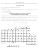 2
2 3
3GENERAL INSTRUCTIONS
This form must be submitted for any application to drill for, test, extract, produce, dispose and/or utilize the actual geothermal resources on Federally leased land or lands covered by a
unit or cooperative agreement.
SPECIFIC INSTRUCTIONS
Item 1C: Show the current status for existing wells: I=injecting, F=flowing, P=pumping, HE=heat exchange, SI=shut-in, WS=water supply, OB=observation, O=other (explain).
Item 7: Number the wells using the Modified Kettleman Well Numbering System (see below).
Item 15: Show the surface location coordinates from the nearest section comer or tract lines and if the well is to be directionally drilled, the proposed zone coordinates (top and bottom)
from the surface location.
Item 19: Indicate reference datum from which measurement was made (see item 20).
Item 20: If the reference datum shown is not the graded mat, also show the measurement from the mat surface (e.g., mat-to-derrick floor (DF) measurement, mat-to-rotary table (RT)
measurement, mat-to-kelly bushing (KB) measurement, etc.)
Item 21: For subsequent well work the latest well conditions along with all proposed additions and changes must be shown. To show current well conditions, either fill out this item or
attach the latest completion report on the subject well.
Item 22: Summarize other pertinent existing data such as producing and injecting zones, type, size, density of perforations and perforated intervals, etc., in addition to the proposed
work. Indicate reasons for changes undertaken.
PROCEDURE FOR NUMBERING GEOTHERMAL WELLS USING THE
MODIFIED KETTLEMAN WELL NUMBERING SYSTEM
1. Subdivide the sections where the wells are to be located into 10-acre (660 feet x 660 feet) subdivisions. Number each horizontal and vertical subdivision starting in the northwest
corner of each section with 1.1 and increasing to the east and south. A regular 640-acre section contains 64 subdivisions numbered from 11 to 88 (vertical digit first followed by the
horizontal digit).
2. Number the first vertical well with the number of the 10-acre subdivision in which it is located followed by the section number. (See examples “A”, “B”, and “C”, below.) If the
first well is directionally drilled, number it with the subdivision number of its surface location, followed by the subdivision number in which the bottom of the completion interval lies
and that section number (if different from the surface section number), and followed by the surface section number. (See Example “D”.)
3. Subsequent wells drilled from the same 10-acre surface location are numbered in the manner described above with an A, B, C, etc., added following the surface subdivision number.
(See Examples “E” and “F”.)
4. For sections with irregular boundaries, align a 10-acre grid pattern North-South, running through the westernmost section point or line and East-West running through the
northernmost section point or line. Number wells according to the 10-acre grid, subdividing as far as possible to the east and south.
Example A
26-35
Example D Directional 88(28-36)-35
Example B
103-36
Example E Directional 33A(86-36)-6
Example C
33-6
Example F Directional 33B(52)-6
(Continued on page 3)
(Form 3260-2, page 2)
ADVERTISEMENT
0 votes
Related Articles
Related forms


Related Categories
Parent category: Legal