Application Form - Alaska'S Aquatic Farm Program - Department Of Natural Resources Page 19
Download a blank fillable Application Form - Alaska'S Aquatic Farm Program - Department Of Natural Resources in PDF format just by clicking the "DOWNLOAD PDF" button.
Open the file in any PDF-viewing software. Adobe Reader or any alternative for Windows or MacOS are required to access and complete fillable content.
Complete Application Form - Alaska'S Aquatic Farm Program - Department Of Natural Resources with your personal data - all interactive fields are highlighted in places where you should type, access drop-down lists or select multiple-choice options.
Some fillable PDF-files have the option of saving the completed form that contains your own data for later use or sending it out straight away.
ADVERTISEMENT
 1
1 2
2 3
3 4
4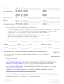 5
5 6
6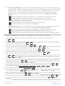 7
7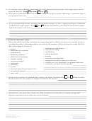 8
8 9
9 10
10 11
11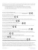 12
12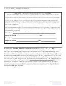 13
13 14
14 15
15 16
16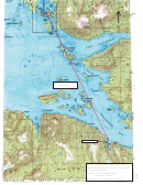 17
17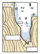 18
18 19
19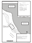 20
20 21
21Example 1: Site Plan and Vicinity Map
Figure 3. Aquatic Farm Site Plan Example
Valdez
Project Area
Parcel 1 - Suspended culture oyster
grow-out area
Area: 5.74 acres
N
Dimensions: 500 feet x 500 feet
---------
Coordinates:
NW: 55° 20.884' N, 133° 2.450' W
NE: 55° 20.884' N 133° 2.407' W
SW: 55° 20.836' N, 133° 2.450' W
SE: 55° 20.836' N, 133° 2.407' W
(Map Datum: NAD83)
--------
Parcel 2 - Hardening Area
Area: 0.57 acre
Dimensions: 50 feet x 50 feet
--------
Coordinates:
NW: 55° 20.884' N, 133° 2.450' W
Community
NE: 55° 20.884' N 133° 2.407' W
SW: 55° 20.836' N, 133° 2.450' W
Subsistence
SE: 55° 20.836' N, 133° 2.407' W
Harvest
US Forest
Tatitlek
(Map Datum: NAD83)
Service
Corporation
(Upland
Land
NW
Owner)
Corner No. 1
NE
(Upland Owner)
Farm boundary 500 ft.
36
33
KELP BED
SAND & MUD
UNDER FARMSITE
39
31
Parcel 1
10’ X 20’
0
100
200
Workraft
1 inch = 250 feet
34
Parcel 2
A’
A
50’ x 50’
N
hardening area
42
Farm boundary 500 ft.
SE
SW
December 2000
Figure 3 - Site Plan
Applicant Name:_____________________________
Name: Big Bay Aquatic Farm (Jane Doe)
Waterway: Prince William Sound, Southwest Boulder Bay
Waterbody: Big Bay
Location:
Section 33,
T11S, R8W, CR M
Region: Prince of Wales Island, SE Alaska
Corner No. 1: Latitude_________________________
Today's date: September 19, 2010
Longitude________________________
Small Boat
Legend
Tatitlek
US Forest
Haulout Area
Oyster long lines (42), 350 feet
Corporation
Service
long, including buoys, block
A’
(Upland
A
See Cross-sectional View of
Land
Longline -- Example 3 diagram
owner)
(Upland Owner)
Depth of water (in feet) at spot
33
where number is located
Aquatic Farm Program
December 2010
Page 17 of 19
ADVERTISEMENT
0 votes
Related Articles
Related forms


 Form Dnr B-108 - Application For Replacement Or Corrected Certificate Of Title, Registration Reprint And/or Replacement Decals - Maryland Department Of Natural Resources
Legal
Form Dnr B-108 - Application For Replacement Or Corrected Certificate Of Title, Registration Reprint And/or Replacement Decals - Maryland Department Of Natural Resources
Legal
 Form Dnr 8477 - Notarized Application For Historic Watercraft Identification Plate Form - Ohio Department Of Natural Resources
Legal
Form Dnr 8477 - Notarized Application For Historic Watercraft Identification Plate Form - Ohio Department Of Natural Resources
Legal

 Form Dnr-b-110 - Certification Of State Of Principal Use - Maryland Department Of Natural Resources
Legal
Form Dnr-b-110 - Certification Of State Of Principal Use - Maryland Department Of Natural Resources
Legal


Related Categories
Parent category: Legal