Voluntary - 43 Cfr 3809 Exploration Notice Form - United States Department Of The Interior Page 2
Download a blank fillable Voluntary - 43 Cfr 3809 Exploration Notice Form - United States Department Of The Interior in PDF format just by clicking the "DOWNLOAD PDF" button.
Open the file in any PDF-viewing software. Adobe Reader or any alternative for Windows or MacOS are required to access and complete fillable content.
Complete Voluntary - 43 Cfr 3809 Exploration Notice Form - United States Department Of The Interior with your personal data - all interactive fields are highlighted in places where you should type, access drop-down lists or select multiple-choice options.
Some fillable PDF-files have the option of saving the completed form that contains your own data for later use or sending it out straight away.
ADVERTISEMENT
 1
1 2
2 3
3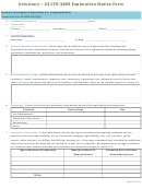 4
4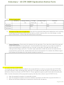 5
5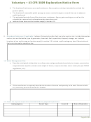 6
6 7
7 8
8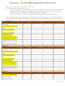 9
9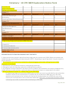 10
10 11
11Voluntary – 43 CFR 3809 Exploration Notice Form
Section 2: Location
Pursuant to 43 CFR 3809.301(b)(2).
1. Legal Description
Principal
Township
Range
Section
Quarter Section
Quarter Quarter Section
Meridian
(North or South)
(East or West)
(NE, SE, SW, NW)
(NE, SE, SW, NW)
County: ______________________________
2. Surface Ownership:
Private
BLM
USFS
State
Other
3.
Access:
Please identify the intended access to work sites. Describe in writing and on the location map.
4.
Maps & Drawings of Operations:
Please include an accurate topographic base map showing the location of the
proposed project with this form. The prospector may submit a U.S.G.S 7.5 minute quadrangle or similar map of
adequate scale that:
a. Provides a general location in relation to major roads, towns, etc.
b. Identifies the proposed prospecting site(s) or activity areas involving surface disturbance. Activity areas
include, but are not limited to, all drill holes, mud pits, excavations, trenches, adits, shafts, tunnels, rock
dumps, stockpiles, impoundments, prospecting roads, etc.; and
c. Includes sufficient detail to identify and locate known prospecting features and facilities that may be
affected and those that are not anticipated to be affected. This includes, but is not limited to, the location
of all drill holes, mud pits, excavations, trenches, adits, shafts, tunnels, rock dumps, stockpiles,
impoundments, prospecting roads, etc. Color photographs, adequately labeled (including date, orientation
and location), of the prospecting site may be used to fulfill this requirement if included with this form.
Page 2 of 11
ADVERTISEMENT
0 votes
Related Articles
Related forms

 Bidder Financial Form - United States Department Of The Interior Bureau Of Ocean Energy Management
Financial
Bidder Financial Form - United States Department Of The Interior Bureau Of Ocean Energy Management
Financial
 And/or A Tunnel Site - United States Department Of The Interior - Bureau Of Land Management - 2016") Form 3830-3 - Notice Of Intent To Locate A Lode Or Placer Mining Claim(s) And/or A Tunnel Site - United States Department Of The Interior - Bureau Of Land Management - 2016
Legal
Form 3830-3 - Notice Of Intent To Locate A Lode Or Placer Mining Claim(s) And/or A Tunnel Site - United States Department Of The Interior - Bureau Of Land Management - 2016
Legal
 Form 1221-2 - Manual Transmittal Sheet - United States Department Of The Interior Bureau Of Land Management
Legal
Form 1221-2 - Manual Transmittal Sheet - United States Department Of The Interior Bureau Of Land Management
Legal
 Recreational Placer Mining On Lands Not Subject To The 1872 Mining Law - United States Department Of The Interior
Legal
Recreational Placer Mining On Lands Not Subject To The 1872 Mining Law - United States Department Of The Interior
Legal
 Request For Ethics Approval To Engage In Outside Work Or Activity - United States Department Of The Interior
Business
Request For Ethics Approval To Engage In Outside Work Or Activity - United States Department Of The Interior
Business


Related Categories
Parent category: Legal