Geographical Regions Of China Page 2
ADVERTISEMENT
 1
1 2
2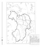 3
3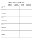 4
4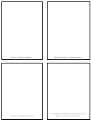 5
5Procedure
1. Introduce the lesson with questions: Where did the earliest civilizations develop? What were some
geographic barriers to expansion? What type of landforms and water bodies do we have in the US?
What geographic barriers were encountered as the US expanded westward? We use these
landforms and water bodies to label regions in our country i.e. Pacific Northwest, Rocky Mountain
States, Midwest, etc. Just as we have a variety of landforms and water bodies, so does China.
Discuss the vocabulary terms. Take students to the computer lab to research the nine geographic
regions of China, using the second web resource listed. Students will label the regions on the map
handout and complete the Regional Matrix (the first website).
2. Divide students into 10 groups, one group for each region. Have each group research more about
that region. Have them complete the Game Card template, making 4 cards for their region: photo of
a physical feature, photo of a human/cultural feature, a description of its climate and
vegetation/crops, and a geographic description of its landforms, water bodies and natural resources.
Read and approve each card to be sure what it says will distinguish that region from another region.
3. Cut the cards apart and use them to play a quiz game with the “big” geographical regions map of
China. (Teacher may make it or students may make it using the regional map, an overhead, shower
curtain and permanent markers.) Lay the shower curtain map on the floor. Gather around the
perimeter in teams of 3-5. Give each team a set of colored craft sticks (i.e. blue team, red team, etc)
with which to show their answer on the big map. Show a card, let team one guess the region. If
correct they place their colored craft stick on that region. If they are incorrect, play passes to the next
team. At the end of the game, have each team count up the number of craft sticks they correctly
placed on the big map. Groups will abstain from their own researched region.
Assessment / Evaluation
Number the geographic regions on a map. Individually, using a 10-sided dice or other method, have the
student role twice so he/she has two different numbers. Have the student compare the two regions in a
Venn Diagram, giving a minimum of 8 facts on the Venn.
ADVERTISEMENT
0 votes
Related Articles
Related forms

 Chinese Visa Application Form - Macao Special Administrative Region Of The People's Republic Of China
Business
Chinese Visa Application Form - Macao Special Administrative Region Of The People's Republic Of China
Business
") Form V.2013 - Visa Application Form Of The People's Republic Of China (for The Mainland Of China Only)
Business
Form V.2013 - Visa Application Form Of The People's Republic Of China (for The Mainland Of China Only)
Business
") General Guidance For Chinese Visa Application, Visa Application Form Of The People's Republic Of China (for The Mainland Of China Only)
Business
General Guidance For Chinese Visa Application, Visa Application Form Of The People's Republic Of China (for The Mainland Of China Only)
Business
") Form V.2013 - Visa Application Form Of The People's Republic Of China (for The Mainland Of China Only)
Business
Form V.2013 - Visa Application Form Of The People's Republic Of China (for The Mainland Of China Only)
Business
 Form G-28i - Notice Of Entry Of Appearance As Attorney In Matters Outside The Geographical Confines Of The United States
Legal
Form G-28i - Notice Of Entry Of Appearance As Attorney In Matters Outside The Geographical Confines Of The United States
Legal
 Instructions For Form G-28i - Notice Of Entry Of Appearance As Attorney In Matters Outside The Geographical Confines Of The United States
Legal
Instructions For Form G-28i - Notice Of Entry Of Appearance As Attorney In Matters Outside The Geographical Confines Of The United States
Legal


Related Categories
Parent category: Education