Voluntary - 43 Cfr 3809 Plan Of Operations Form - United States Department Of The Interior Page 16
Download a blank fillable Voluntary - 43 Cfr 3809 Plan Of Operations Form - United States Department Of The Interior in PDF format just by clicking the "DOWNLOAD PDF" button.
Open the file in any PDF-viewing software. Adobe Reader or any alternative for Windows or MacOS are required to access and complete fillable content.
Complete Voluntary - 43 Cfr 3809 Plan Of Operations Form - United States Department Of The Interior with your personal data - all interactive fields are highlighted in places where you should type, access drop-down lists or select multiple-choice options.
Some fillable PDF-files have the option of saving the completed form that contains your own data for later use or sending it out straight away.
ADVERTISEMENT
 1
1 2
2 3
3 4
4 5
5 6
6 7
7 8
8 9
9 10
10 11
11 12
12 13
13 14
14 15
15 16
16 17
17 18
18 19
19 20
20 21
21 22
22 23
23 24
24 25
25 26
26 27
27 28
28 29
29 30
30 31
31 32
32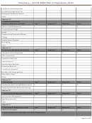 33
33 34
34 35
35 36
36Voluntary – 43 CFR 3809 Plan of Operations Form
5. Calculated porosity
6. Constant head analyses for saturated hydraulic conductivity test
7. Hanging column
8. Pressure plate
9. Unsaturated hydraulic conductivity
10. Proctor compaction
V.
Infiltration Modeling needed, such as Heap Leach Draindown Estimation, Tailings Impoundment
Draindown Estimation, cap/cover materials, etc.
VI. Waste Rock Management Plan
1. Work plan history with geochemical and geotechnical summaries.
2. Operating/post reclamation management of the waste rock dumps (WRDs)
3. Describe mining sequence of rock types/volumes/final disposition (see section III.2 above).
4. Describe how potentially acid generating (PAG) rock will be selectively mined, segregated and managed
to preclude exposure to air and water. Need to address metals mobility/accumulation for both PAG and
non-PAG materials (see section III.5.c).
5. For each benign and PAG WRD facility, include a text description for: toe elevation, crest elevation,
ultimate height, reclaimed slope, plan dimensions, tonnage capacity and acres. Provide a summary
table for volumes by facility for life-of-mine (LOM).
6. Supplement the text with plan and cross sectional drawings showing: plan views and related
alluvial/cover stockpile locations, cross sectional views showing operational and post reclamation
slopes, grades, toe and crest elevations, existing ground slope and cap thicknesses for LOM.
7. For pit backfill scenarios, include the same text and supporting drawings previously described, describe
any amendment requirements. Provide information on the total volume to be backfilled with rock type
and its origin, final backfill elevation and rebound ground water elevation.
8. Tailings impoundments, heaps, ore stockpiles, topsoil stockpiles should include the same text and
supporting drawings previously described.
Page 16 of 36
ADVERTISEMENT
0 votes
Related Articles
Related forms


 Bidder Financial Form - United States Department Of The Interior Bureau Of Ocean Energy Management
Financial
Bidder Financial Form - United States Department Of The Interior Bureau Of Ocean Energy Management
Financial


 And/or A Tunnel Site - United States Department Of The Interior - Bureau Of Land Management - 2016") Form 3830-3 - Notice Of Intent To Locate A Lode Or Placer Mining Claim(s) And/or A Tunnel Site - United States Department Of The Interior - Bureau Of Land Management - 2016
Legal
Form 3830-3 - Notice Of Intent To Locate A Lode Or Placer Mining Claim(s) And/or A Tunnel Site - United States Department Of The Interior - Bureau Of Land Management - 2016
Legal
 Form 1221-2 - Manual Transmittal Sheet - United States Department Of The Interior Bureau Of Land Management
Legal
Form 1221-2 - Manual Transmittal Sheet - United States Department Of The Interior Bureau Of Land Management
Legal
 Form 5-5519 - Cash Penal Bond For Grazing Permits -department Of The Interior Bureau Of Indian Affairs
Legal
Form 5-5519 - Cash Penal Bond For Grazing Permits -department Of The Interior Bureau Of Indian Affairs
Legal


Related Categories
Parent category: Legal