Fema Form 086-0-33 - Elevation Certificate - U.s. Department Of Homeland Security Page 10
ADVERTISEMENT
 1
1 2
2 3
3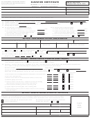 4
4 5
5 6
6 7
7 8
8 9
9 10
10 11
11 12
12 13
13 14
14 15
15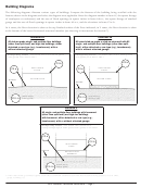 16
16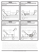 17
17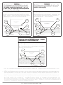 18
18 19
19 20
20 21
21 22
22 23
23instructions for Completing
U.S. DEPARTMENT OF HOMELAND SECURITY
OMB No. 1660-0008
FEDERAL EMERGENCY MANAGEMENT AGENCY
the Elevation Certificate
Expiration Date: July 31, 2015
National Flood Insurance Program
The Elevation Certificate is to be completed by a land surveyor, engineer, or architect who is authorized by law to certify elevation
information when elevation information is required for Zones A1–A30, AE, AH, A (with BFE), VE, V1–V30, V (with BFE),
AR, AR/A, AR/AE, AR/A1–A30, AR/AH, or AR/AO. Community officials who are authorized by law or ordinance to provide
floodplain management information may also complete this form. For Zones AO and A (without BFE), a community official,
a property owner, or an owner’s representative may provide information on this certificate, unless the elevations are intended
for use in supporting a request for a LOMA or LOMR-F. Certified elevations must be included if the purpose of completing the
Elevation Certificate is to obtain a LOMA or LOMR-F.
The property owner, the owner’s representative, or local official who is authorized by law to administer the community
floodplain ordinance can complete Section A and Section B. The partially completed form can then be given to the land surveyor,
engineer, or architect to complete Section C. The land surveyor, engineer, or architect should verify the information provided by
the property owner or owner’s representative to ensure that this certificate is complete.
In Puerto Rico only, elevations for building information and flood hazard information may be entered in meters.
SECtion A – ProPErtY inForMAtion
items a1–a4. This section identifies the building, its location, and its owner. Enter the name(s) of the building owner(s),
the building’s complete street address, and the lot and block numbers. If the building’s address is different from the owner’s
address, enter the address of the building being certified. If the address is a rural route or a Post Office box number, enter the
lot and block numbers, the tax parcel number, the legal description, or an abbreviated location description based on distance
and direction from a fixed point of reference. For the purposes of this certificate, “building” means both a building and a
manufactured (mobile) home.
A map may be attached to this certificate to show the location of the building on the property. A tax map, FIRM, or detailed
community map is appropriate. If no map is available, provide a sketch of the property location, and the location of the building
on the property. Include appropriate landmarks such as nearby roads, intersections, and bodies of water. For building use,
indicate whether the building is residential, non-residential, an addition to an existing residential or non-residential building,
an accessory building (e.g., garage), or other type of structure. Use the Comments area of the appropriate section if needed, or
attach additional comments.
item a5. Provide latitude and longitude coordinates for the center of the front of the building. Use either decimal degrees (e.g.,
39.5043°, -110.7585°) or degrees, minutes, seconds (e.g., 39° 30' 15.5", -110° 45' 30.7") format. If decimal degrees are used,
provide coordinates to at least 4 decimal places or better. When using degrees, minutes, seconds, provide seconds to at least 1
decimal place or better. The latitude and longitude coordinates must be accurate within 66 feet. When the latitude and longitude
are provided by a surveyor, check the “Yes” box in Section D and indicate the method used to determine the latitude and longitude
in the Comments area of Section D. If the Elevation Certificate is being certified by other than a licensed surveyor, engineer, or
architect, this information is not required. Provide the type of datum used to obtain the latitude and longitude. FEMA prefers the
use of NAD 1983.
item a6. If the Elevation Certificate is being used to obtain flood insurance through the NFIP, the certifier must provide at least 2
photographs showing the front and rear of the building taken within 90 days from the date of certification. The photographs must
be taken with views confirming the building description and diagram number provided in Section A. To the extent possible, these
photographs should show the entire building including foundation. If the building has split-level or multi-level areas, provide
at least 2 additional photographs showing side views of the building. In addition, when applicable, provide a photograph of the
foundation showing a representative example of the flood openings or vents. All photographs must be in color and measure at
least 3" × 3". Digital photographs are acceptable.
item a7. Select the diagram on pages 7–9 that best represents the building. Then enter the diagram number and use the diagram
to identify and determine the appropriate elevations requested in Items C2.a–h. If you are unsure of the correct diagram, select
the diagram that most closely resembles the building being certified.
item a8.a Provide the square footage of the crawlspace or enclosure(s) below the lowest elevated floor of an elevated building
with or without permanent flood openings. Take the measurement from the outside of the crawlspace or enclosure(s). Examples
of elevated buildings constructed with crawlspace and enclosure(s) are shown in Diagrams 6–9 on pages 8–9. Diagram 2, 4, or 9
should be used for a building constructed with a crawlspace floor that is below the exterior grade on all sides.
NFIP Elevation Certificate Instructions – Page 1
ADVERTISEMENT
0 votes
Related Articles
Related forms


Related Categories
Parent category: Legal