Fema Form 086-0-33 Elevation Certificate Page 11
Download a blank fillable Fema Form 086-0-33 Elevation Certificate in PDF format just by clicking the "DOWNLOAD PDF" button.
Open the file in any PDF-viewing software. Adobe Reader or any alternative for Windows or MacOS are required to access and complete fillable content.
Complete Fema Form 086-0-33 Elevation Certificate with your personal data - all interactive fields are highlighted in places where you should type, access drop-down lists or select multiple-choice options.
Some fillable PDF-files have the option of saving the completed form that contains your own data for later use or sending it out straight away.
ADVERTISEMENT
 1
1 2
2 3
3 4
4 5
5 6
6 7
7 8
8 9
9 10
10 11
11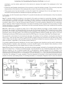 12
12 13
13 14
14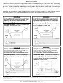 15
15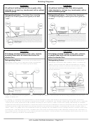 16
16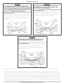 17
17Instructions for Completing the Elevation Certificate (continued)
Item B2. County Name. Enter the name of the county or counties in which the community is located. For an
unincorporated area of a county, enter "unincorporated area." For an independent city, enter "independent city."
Item B3. State. Enter the 2-letter state abbreviation (for example, VA, TX, CA).
Items B4–B5. Map/Panel Number and Suffix. Enter the 10-character "Map Number" or "Community Panel Number"
shown on the FIRM where the building or manufactured (mobile) home is located. For maps in a county-wide format,
the sixth character of the "Map Number" is the letter "C" followed by a 4-digit map number. For maps not in a county-
wide format, enter the "Community Panel Number" shown on the FIRM.
Item B6. FIRM Index Date. Enter the effective date or the map revised date shown on the FIRM Index.
Item B7. FIRM Panel Effective/Revised Date. Enter the map effective date or the map revised date shown on the
FIRM panel. This will be the latest of all dates shown on the map. The current FIRM panel effective date can be
determined by calling 1-800-358-9616.
Item B8. Flood Zone(s). Enter the flood zone, or flood zones, in which the building is located. All flood zones
containing the letter "A" or "V" are considered Special Flood Hazard Areas. The flood zones are A, AE, A1–A30, V,
VE, V1–V30, AH, AO, AR, AR/A, AR/AE, AR/A1–A30, AR/AH, and AR/AO. Each flood zone is defined in the legend of
the FIRM panel on which it appears.
Item B9. Base Flood Elevation(s). Using the appropriate Flood Insurance Study (FIS) Profile, Floodway Data Table, or
FIRM panel, locate the property and enter the BFE (or base flood depth) of the building site. If the building is located
in more than 1 flood zone in Item B8, list all appropriate BFEs in Item B9. BFEs are shown on a FIRM or FIS Profile
for Zones A1–A30, AE, AH, V1–V30, VE, AR, AR/A, AR/AE, AR/A1–A30, AR/AH, and AR/AO; flood depth numbers are
shown for Zone AO. Use the AR BFE if the building is located in any of Zones AR/A, AR/AE, AR/A1–A30, AR/AH, or
AR/AO. In A or V zones where BFEs are not provided on the FIRM, BFEs may be available from another source. For
example, the community may have established BFEs or obtained BFE data from other sources for the building site.
For subdivisions and other developments of more than 50 lots or 5 acres, establishment of BFEs is required by the
community's floodplain management ordinance. If a BFE is obtained from another source, enter the BFE in Item B9.
In an A Zone where BFEs are not available, complete Section E and enter N/A for Section B, Item B9. Enter the BFE
to the nearest tenth of a foot (nearest tenth of a meter, in Puerto Rico).
Item B10. Indicate the source of the BFE that you entered in Item B9. If the BFE is from a source other than FIS
Profile, FIRM, or community, describe the source of the BFE.
Item B11. Indicate the elevation datum to which the elevations on the applicable FIRM are referenced as shown on
the map legend. The vertical datum is shown in the Map Legend and/or the Notes to Users on the FIRM.
Item B12. Indicate whether the building is located in a Coastal Barrier Resources System (CBRS) area or Otherwise
Protected Area (OPA). (OPAs are portions of coastal barriers that are owned by Federal, State, or local governments
or by certain non-profit organizations and used primarily for natural resources protection.) Federal flood insurance is
prohibited in designated CBRS areas or OPAs for buildings or manufactured (mobile) homes built or substantially
improved after the date of the CBRS or OPA designation. For the first CBRS designations, that date is October 1,
1983. Information about CBRS areas and OPAs may be obtained on the FEMA web site at https://
national-flood-insurance-program/coastal-barrier-resources-system.
SECTION C – BUILDING ELEVATION INFORMATION (SURVEY REQUIRED)
Complete Section C if the building is located in any of Zones A1–A30, AE, AH, A (with BFE), VE, V1–V30, V (with
BFE), AR, AR/A, AR/AE, AR/A1–A30, AR/AH, or AR/AO, or if this certificate is being used to support a request for a
LOMA or LOMR-F. If the building is located in Zone AO or Zone A (without BFE), complete Section E instead. To
ensure that all required elevations are obtained, it may be necessary to enter the building (for instance, if the building
has a basement or sunken living room, split-level construction, or machinery and equipment).
Surveyors may not be able to gain access to some crawlspaces to shoot the elevation of the crawlspace floor. If
access to the crawlspace is limited or cannot be gained, follow one of these procedures.
• Use a yardstick or tape measure to measure the height from the floor of the crawlspace to the "next higher floor,"
and then subtract the crawlspace height from the elevation of the "next higher floor." If there is no access to the
NFIP Elevation Certificate Instructions – Page 3 of 9
ADVERTISEMENT
0 votes
Related Articles
Related forms


Related Categories
Parent category: Business