Fema Form 086-0-33 Elevation Certificate Page 6
Download a blank fillable Fema Form 086-0-33 Elevation Certificate in PDF format just by clicking the "DOWNLOAD PDF" button.
Open the file in any PDF-viewing software. Adobe Reader or any alternative for Windows or MacOS are required to access and complete fillable content.
Complete Fema Form 086-0-33 Elevation Certificate with your personal data - all interactive fields are highlighted in places where you should type, access drop-down lists or select multiple-choice options.
Some fillable PDF-files have the option of saving the completed form that contains your own data for later use or sending it out straight away.
ADVERTISEMENT
 1
1 2
2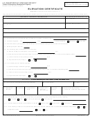 3
3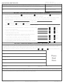 4
4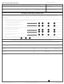 5
5 6
6 7
7 8
8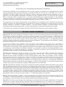 9
9 10
10 11
11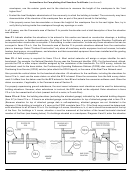 12
12 13
13 14
14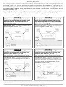 15
15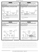 16
16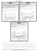 17
17OMB No. 1660-0008
ELEVATION CERTIFICATE
Expiration Date: November 30, 2018
IMPORTANT: In these spaces, copy the corresponding information from Section A.
FOR INSURANCE COMPANY USE
Building Street Address (including Apt., Unit, Suite, and/or Bldg. No.) or P.O. Route and Box No.
Policy Number:
City
State
ZIP Code
Company NAIC Number
SECTION G – COMMUNITY INFORMATION (OPTIONAL)
The local official who is authorized by law or ordinance to administer the community's floodplain management ordinance can complete
Sections A, B, C (or E), and G of this Elevation Certificate. Complete the applicable item(s) and sign below. Check the measurement
used in Items G8–G10. In Puerto Rico only, enter meters.
The information in Section C was taken from other documentation that has been signed and sealed by a licensed surveyor,
G1.
engineer, or architect who is authorized by law to certify elevation information. (Indicate the source and date of the elevation
data in the Comments area below.)
A community official completed Section E for a building located in Zone A (without a FEMA-issued or community-issued BFE)
G2.
or Zone AO.
The following information (Items G4–G10) is provided for community floodplain management purposes.
G3.
G4. Permit Number
G5. Date Permit Issued
G6. Date Certificate of
Compliance/Occupancy Issued
G7. This permit has been issued for:
New Construction
Substantial Improvement
G8. Elevation of as-built lowest floor (including basement)
feet
meters
of the building:
Datum
feet
meters
G9. BFE or (in Zone AO) depth of flooding at the building site:
Datum
feet
meters
G10. Community's design flood elevation:
Datum
Local Official's Name
Title
Community Name
Telephone
Signature
Date
Comments (including type of equipment and location, per C2(e), if applicable)
Check here if attachments.
Form Page 4 of 6
FEMA Form 086-0-33 (7/15)
Replaces all previous editions.
ADVERTISEMENT
0 votes
Related Articles
Related forms


Related Categories
Parent category: Business