Ics Form 209 - Incident Status Summary Page 10
Download a blank fillable Ics Form 209 - Incident Status Summary in PDF format just by clicking the "DOWNLOAD PDF" button.
Open the file in any PDF-viewing software. Adobe Reader or any alternative for Windows or MacOS are required to access and complete fillable content.
Complete Ics Form 209 - Incident Status Summary with your personal data - all interactive fields are highlighted in places where you should type, access drop-down lists or select multiple-choice options.
Some fillable PDF-files have the option of saving the completed form that contains your own data for later use or sending it out straight away.
ADVERTISEMENT
 1
1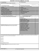 2
2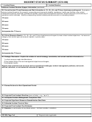 3
3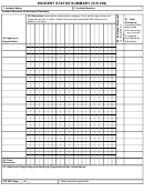 4
4 5
5 6
6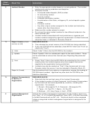 7
7 8
8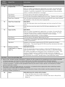 9
9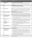 10
10 11
11 12
12 13
13 14
14 15
15 16
16 17
17 18
18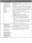 19
19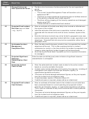 20
20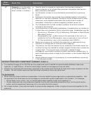 21
21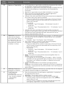 22
22 23
23Block
Block Title
Instructions
Number
*17
County / Parish /
REQUIRED BLOCK WHEN APPLICABLE.
Borough
• Enter the county, parish, or borough where the incident originated.
• If other counties or jurisdictions are involved, enter them in Block 25 or
Block 47.
*18
City
REQUIRED BLOCK WHEN APPLICABLE.
• Enter the city where the incident originated.
• If other cities or jurisdictions are involved, enter them in Block 25 or Block
47.
19
Unit or Other
Enter the unit, sub-unit, unit identification (ID) number or code (if used), or
other information about where the incident originated. This may be a local
identifier that indicates primary incident jurisdiction or responsibility (e.g.,
police, fire, public works, etc.) or another type of organization. Enter
specifics in Block 25.
*20
Incident Jurisdiction
REQUIRED BLOCK WHEN APPLICABLE.
Enter the jurisdiction where the incident originated (the entry may be
general, such as Federal, city, or State, or may specifically identify agency
names such as Warren County, U.S. Coast Guard, Panama City, NYPD).
• When relevant, indicate the ownership of the area where the incident
21
Incident Location
Ownership (if different
originated, especially if it is different than the agency having jurisdiction.
• This may include situations where jurisdictions contract for emergency
than jurisdiction)
services, or where it is relevant to include ownership by private entities,
such as a large industrial site.
• Enter the longitude and latitude where the incident originated, if available
22
22. Longitude (indicate
format):
and normally used by the authority having jurisdiction for the incident.
• Clearly label the data, as longitude and latitude can be derived from
various sources. For example, if degrees, minutes, and seconds are
Latitude (indicate
used, label as “33 degrees, 45 minutes, 01 seconds.”
format):
• Enter the US National Grid (USNG) reference where the incident
23
US National Grid
Reference
originated, if available and commonly used by the agencies/jurisdictions
with primary responsibility for the incident.
• Clearly label the data.
• Enter the legal description where the incident originated, if available and
24
Legal Description
(township, section, range)
commonly used by the agencies/jurisdictions with primary responsibility
for the incident.
• Clearly label the data (e.g., N 1/2 SE 1/4, SW 1/4, S24, T32N, R18E).
*25
Short Location or Area
REQUIRED BLOCK.
Description (list all
• List all affected areas as described in instructions for Blocks 16–24
affected areas or a
above, OR summarize a general location, OR list a reference point for
reference point)
the incident (e.g., “the southern third of Florida,” “in ocean 20 miles west
of Catalina Island, CA,” or “within a 5 mile radius of Walden, CO”).
• This information is important for readers unfamiliar with the area (or with
other location identification systems) to be able to quickly identify the
general location of the incident on a map.
• Other location information may also be listed here if needed or relevant
for incident support (e.g., base meridian).
26
UTM Coordinates
Indicate Universal Transverse Mercator reference coordinates if used by the
discipline or jurisdiction.
ADVERTISEMENT
0 votes
Related Articles
Related forms


Related Categories
Parent category: Legal