Aircraft Accident Brief Ntsb/aab-02/01 (Pb2002-910401): Egypt Air Flight 990, Boeing 767-366er, Su-Gap - National Transportation Safety Board Page 40
ADVERTISEMENT
: Egypt Air Flight 990, Boeing 767-366er, Su-Gap - National Transportation Safety Board Printable pdf") 1
1  2
2  3
3  4
4  5
5  6
6  7
7  8
8  9
9  10
10  11
11  12
12  13
13  14
14  15
15 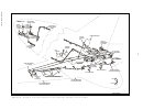 16
16 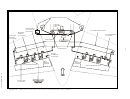 17
17  18
18  19
19 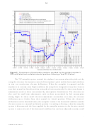 20
20  21
21  22
22  23
23  24
24  25
25  26
26  27
27  28
28  29
29  30
30  31
31 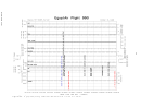 32
32 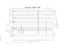 33
33 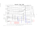 34
34  35
35  36
36  37
37  38
38 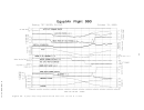 39
39  40
40  41
41  42
42  43
43  44
44  45
45  46
46  47
47  48
48  49
49  50
50  51
51  52
52  53
53  54
54  55
55  56
56  57
57  58
58  59
59  60
60  61
61  62
62  63
63  64
64  65
65  66
66  67
67  68
68  69
69  70
70  71
71  72
72  73
73  74
74  75
75  76
76  77
77  78
78  79
79  80
80  81
81  82
82  83
83  84
84  85
85  86
86  87
87  88
88  89
89  90
90  91
91  92
92  93
93  94
94  95
95  96
96  97
97  98
98  99
99  100
100  101
101  102
102  103
103  104
104  105
105  106
106  107
107  108
108  109
109  110
110  111
111  112
112  113
113  114
114  115
115  116
116  117
117  118
118  119
119  120
120  121
121  122
122  123
123  124
124  125
125  126
126  127
127  128
128  129
129  130
130  131
131  132
132  133
133  134
134  135
135  136
136  137
137  138
138  139
139  140
140  141
141  142
142  143
143  144
144  145
145  146
146  147
147  148
148  149
149  150
150  151
151  152
152  153
153  154
154  155
155  156
156  157
157  158
158  159
159  160
160 34
WRECKAGE INFORMATION
About 70 percent of the airplane was recovered during the initial recovery
operations, which began on the morning of October 31 and ended on December 22, 1999.
Subsequent recovery efforts conducted between March 29 and April 3, 2000, resulted in
the recovery of the left engine and additional pieces of airplane wreckage.
Sonar mapping of the wreckage site depicted two distinct underwater debris fields,
which were identified by recovery personnel and investigators as the western and eastern
debris fields. These debris fields were about 366 meters (1,200 feet) apart from center
point to center point. The western debris field, which was estimated to be 62 meters by
66 meters and was centered about 40° 20' 57" north latitude, 69° 45' 40" west longitude,
contained mainly parts associated with the left engine and various other small pieces of
wreckage (including portions of two wing panels, fuselage skin, horizontal stabilizer skin,
and the majority of the nose landing gear assembly). The eastern debris field, which was
estimated to be 83 meters by 73 meters and was centered about 40° 20' 51" north latitude,
69° 45' 24" west longitude, contained the bulk of the airplane’s fuselage, wings,
empennage (including the outboard tips of the right and left elevators and all recovered
elevator PCAs), right engine, main landing gear, and flight recorders. Many pieces of
54
floating wreckage (including pieces of the right and left elevator surfaces)
were
recovered from the water’s surface in or near the eastern debris field shortly after the
accident; specific recovery locations for some of these pieces were not noted. The small
size of most of the recovered pieces of wreckage was consistent with the airplane
impacting the water at a high speed. The locations of the two main wreckage debris fields
were consistent with the accident airplane’s flightpath, as indicated by the primary radar
55
data.
The Safety Board leased a commercial vessel to recover the wreckage that had
settled on the ocean floor. Pieces of wreckage were recovered from a depth of about
230 feet using a clamshell scoop and a crane, loaded (using a front loader) into containers
on the recovery vessel, and moved to shore. Upon reaching shore, the containers of
wreckage were lifted off the recovery vessel and rinsed thoroughly twice. The containers
were then moved into the hangar at Quonset Point, Rhode Island, where they were tipped
onto their sides. The wreckage was then moved out of the containers onto the floor using
rakes and shovels. Once on the hangar floor, the wreckage was spread evenly by a front
loader to assist the drying process. During this process, FBI and Safety Board
investigators examined the recovered wreckage for evidence of fire or explosion damage.
The FBI placed identification tags on some of the debris; accident investigators then
documented all of the debris.
Four of the elevators’ six PCAs (the center and outboard right elevator PCAs and
56
two elevator PCAs whose positions could not be determined)
were recovered.
Postaccident examination revealed that all four of the recovered PCAs exhibited
54
In total, about 37 percent of the total elevator surface area was recovered.
55
For additional information, see the section titled, “Review of Radar Data.”
NTSB/AAB-02/01
ADVERTISEMENT
0 votes
Related Articles
Related forms
 Investigation Party Form")


 During An Allegiant Air Flight")


Related Categories
Parent category: Legal